The Planetary Registry: Mapping Mars Together
How the Martian Republic's planetary registry works — a cooperative geographic data initiative mapping settlements, research stations, terrain features, and Mars facts. From Olympus City to Utopia Planitia Shipyards.
A Planet Without Maps
When the first permanent settlers arrive on Mars, they will inherit a planet with orbital imagery and rover-scale ground truth for a handful of sites. The vast majority of the Martian surface — 144.8 million square kilometers of it — will be unmapped at the resolution that matters for settlement: where is the ice, where is the stable ground, where are the lava tubes, where does the terrain allow safe rover transit?
Building this knowledge is not a task for a single expedition or a central mapping authority. It is a generational, cooperative effort — every citizen who ventures beyond the habitat perimeter contributes to the collective understanding of the terrain.
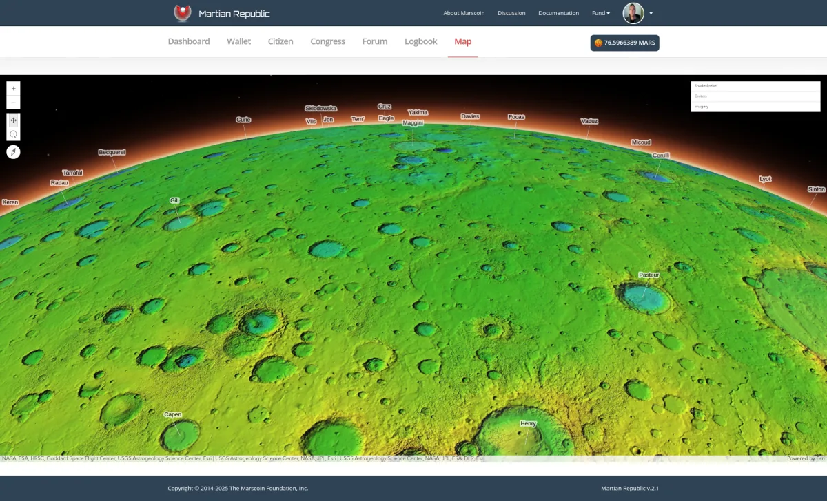
The Martian Republic’s planetary registry is the infrastructure for this effort. It is a blockchain-anchored geographic database where citizens contribute location data, terrain observations, resource discoveries, and settlement information. Every contribution is signed, timestamped, and permanently recorded.
How the Registry Works
Contributing Data
Any verified citizen can submit a registry entry through the Martian Republic application. Each entry includes:
- Coordinates — areographic latitude and longitude (Mars uses its own coordinate system, analogous to geographic coordinates on Earth)
- Name — the designated name for the feature or location
- Type — settlement, research station, terrain feature, resource deposit, hazard zone, point of interest, or transportation route
- Description — detailed information about the location
- Supporting data — photographs, survey measurements, LIDAR scans, or other attachments stored on IPFS
- Contributor — automatically attributed via the citizen’s cryptographic signature
- Timestamp — automatically recorded on the Marscoin blockchain
Verification and Dispute Resolution
Because registry entries are signed and timestamped, the community has a clear record of who contributed what and when. If two citizens submit conflicting information about the same location, the blockchain record provides objective evidence for resolution. Community governance (via congressional voting) can adjudicate disputes about naming, boundaries, and classification.
Over time, locations accumulate multiple contributions from different citizens — additional observations, updated measurements, new photographs — building increasingly detailed profiles of each registered site.
The Settlements of Mars
The planetary registry includes data on the settlements that form the backbone of Martian civilization. Here are the primary settlements registered in the current system:
Olympus City
Type: Capital settlement Population: 1,840 Location: Northern lowlands, near the base of Olympus Mons
Olympus City is the capital of the Martian Republic and the largest permanent settlement on Mars. It serves as the administrative center for governance, the primary hub for interplanetary logistics (receiving cargo from Earth), and the home base for the largest concentration of scientists, engineers, and support personnel.
The city is built around a central pressurized complex with radiating habitat modules, connected by enclosed walkways. Major facilities include the central governance hall, primary medical center, main greenhouse complex, fabrication workshops, and the Marscoin mining node cluster that anchors the settlement’s blockchain infrastructure.
Valles Marineris Outpost
Type: Research station Population: 240 Location: Central Valles Marineris canyon system
Situated within the largest canyon system in the solar system (up to 7 km deep and 4,000 km long), the Valles Marineris Outpost is dedicated to geological research. Scientists here study the exposed rock strata visible in the canyon walls — a geological record spanning billions of years of Martian history.
The outpost specializes in mineralogy, atmospheric science (the canyon creates unique weather patterns), and the search for subsurface water. Its position deep within the canyon provides natural radiation shielding from the canyon walls.
Gale Research Station
Type: Research station Population: 120 Location: Gale Crater, near the base of Mount Sharp (Aeolis Mons)
Gale Crater was selected for research because of its extraordinary geological diversity — the same qualities that led NASA to land the Curiosity rover there in 2012. The station continues the work that Curiosity began, with human researchers able to conduct analyses that no rover could.
The station’s focus areas include sedimentary geology, the history of water on Mars, and the search for biosignatures in ancient lake-bed sediments. Mount Sharp’s layered deposits provide a stratigraphic record that researchers are systematically surveying.
Jezero Colony
Type: Agricultural and research settlement Population: 380 Location: Jezero Crater
Jezero Crater, once home to an ancient river delta, has soil properties that make it one of the most promising sites for Martian agriculture. The colony’s primary mission is developing and scaling agricultural techniques for Mars — testing crop varieties, soil amendment strategies, and greenhouse designs in actual Martian conditions.
Jezero Colony produces a significant portion of the Martian food supply, specializing in potatoes, soybeans, wheat, and leafy greens. The colony also continues astrobiological research in the ancient delta sediments, building on the work of NASA’s Perseverance rover.
Utopia Planitia Shipyards
Type: Industrial facility Population: 560 Location: Utopia Planitia, northern lowlands
The Shipyards are Mars’s primary industrial complex, responsible for manufacturing, vehicle assembly, construction material production, and heavy equipment maintenance. The name pays homage to science fiction tradition while describing a real function: this is where Mars builds things.
Key operations include regolith processing (for construction materials and water extraction), solar panel manufacturing, rover assembly and repair, habitat module fabrication, and fuel production for surface vehicles. The Shipyards represent Mars’s growing capacity for industrial self-sufficiency — every item manufactured locally is one less item that must be shipped from Earth.
Mars: The Planet
The planetary registry exists within the context of Mars itself — a world with conditions unlike anything on Earth. Understanding these conditions is essential for interpreting registry data.
Key Facts
| Parameter | Value |
|---|---|
| Diameter | 6,779 km (53% of Earth’s) |
| Surface gravity | 3.72 m/s (38% of Earth’s) |
| Average surface temperature | -60C (-76F) |
| Atmosphere | 95.3% CO, 2.7% N, 0.13% O — less than 1% of Earth’s pressure |
| Day length (Sol) | 24 hours, 39 minutes, 35 seconds |
| Year length | 668.6 Sols (687 Earth days) |
| Distance from Sun | 1.52 AU (average) |
| Moons | Phobos (22 km) and Deimos (12 km) |
What This Means for Settlement
Low gravity affects everything from construction engineering to human health. Buildings can be taller and lighter, but long-term physiological effects on the human body (bone density loss, cardiovascular changes) require ongoing medical monitoring.
Thin atmosphere provides almost no radiation shielding, no breathable air, and insufficient pressure for liquid water on the surface. All habitats must be pressurized and radiation-shielded. The atmosphere is, however, a source of CO for fuel production via the Sabatier reaction.
Cold temperatures require heating for all habitats and limit the operating conditions for surface equipment. However, the cold also provides excellent passive cooling for computing equipment (including mining nodes) and natural cold storage for supplies.
Dust is both a resource (regolith for construction) and a hazard (perchlorates in the soil are toxic, dust storms can last months and reduce solar power dramatically). The planetary registry tracks dust storm patterns and perchlorate concentrations across surveyed areas.
Cooperative Cartography
The planetary registry embodies a principle: the map of Mars belongs to everyone who helps make it.
Every citizen who surveys a new area, measures a resource deposit, photographs a terrain feature, or documents a hazard contributes to the collective map. Every contribution is credited, timestamped, and permanent. The registry grows organically as the settlement expands, building from a sparse collection of surveyed sites into a comprehensive atlas.
This model — cooperative, attributed, blockchain-anchored — has advantages over both centralized mapping (where a single authority controls what goes on the map) and unstructured crowdsourcing (where contributions are anonymous and unverifiable):
- Attribution ensures accountability. If a survey report is inaccurate, the community knows who submitted it and can follow up.
- Timestamps establish priority. Who discovered a resource deposit first? The blockchain knows.
- Immutability prevents manipulation. Geographic data cannot be altered to benefit one faction or conceal information from others.
- Transparency enables planning. All citizens have equal access to the same geographic intelligence, enabling informed governance decisions about expansion, resource allocation, and exploration priorities.
Using the Registry Today
The planetary registry is live in the Martian Republic application. Today, the community uses it to explore the registered settlements, study Mars geography, and contribute to the growing body of location data. It is both an educational tool and a functional prototype.
When settlers begin using it on Mars — registering the actual coordinates of their habitat, documenting the terrain they traverse, marking water ice deposits and lava tube entrances — the registry will be ready. It will have been tested, refined, and improved by years of community use on Earth.
The map of Mars starts here.
To understand how resource data connects to geographic locations, see Resource Inventory: Tracking Life on Mars. For the governance system that decides how mapped resources are used, see Congressional Voting: Direct Democracy on the Blockchain. For the full governance architecture, see The Martian Republic: Blockchain Governance for Mars.